 Membership
 Donate


The Domínguez-Escalante Expedition in Ute Country
Two Spanish priests launched a pivotal chapter in North American history just weeks after American colonists declared their independence from Great Britain. Their journey through what became Colorado was a harbinger of changes to come for the state’s Native peoples.
In the late summer of 1776, ten men traveling out of New Mexico into the heart of modern Colorado stopped along the Dolores River and gazed at a ruin on its south bank. The ruin was in one respect unsurprising; similar in so many ways to the pueblos of New Mexico. At the same time, it confirmed the existence of a previously unknown, if abandoned, Native settlement situated beyond New Mexico. Likely over 600 years old at that moment, the ruin glared back at them from across the centuries. It presented an indication of how very little these men knew about the interior of North America and the deep connection between Indigenous communities and their homelands. For generations, these remains of depopulated Native settlements fueled fantastic imaginings of what lay just beyond New Spain’s northernmost frontier, filtering southward where they took on a life of their own. In the early years of Spanish influence in North America, the wild exploits of Álvar Núñez Cabeza de Vaca and the rumored Seven Cities of Cíbola propelled a series of expeditions into the continent’s interior, lured by the prospect of riches in gold. Francisco Vázquez de Coronado’s 1540 expedition discredited some of these myths and legends, but also established new horizons of mystery still further beyond the grasp of comprehension.
For the men gazing across the Dolores River deep inside the Ute homelands in 1776, the place that is now Colorado constituted an unexplored expanse of exotic and lucrative possibilities—a place where the bearded descendants of wayward Spaniards lived in concert with Native Tribes and the potential discovery of silver deposits lay around every corner. Contemporary maps marked the region as Teguayó and alluded to the existence of legendary locations such as the Sierra Azul and Lake Copala. The men who traveled through Colorado in 1776, however, were not seeking merely to confirm or dispel myths. Instead, they were part of an ambitious effort to bring the land and peoples of the Colorado Plateau and Great Basin into closer view and forge points of entry that would allow the Catholic faith and Spanish empire to project their influence deep into the heart of the continent.
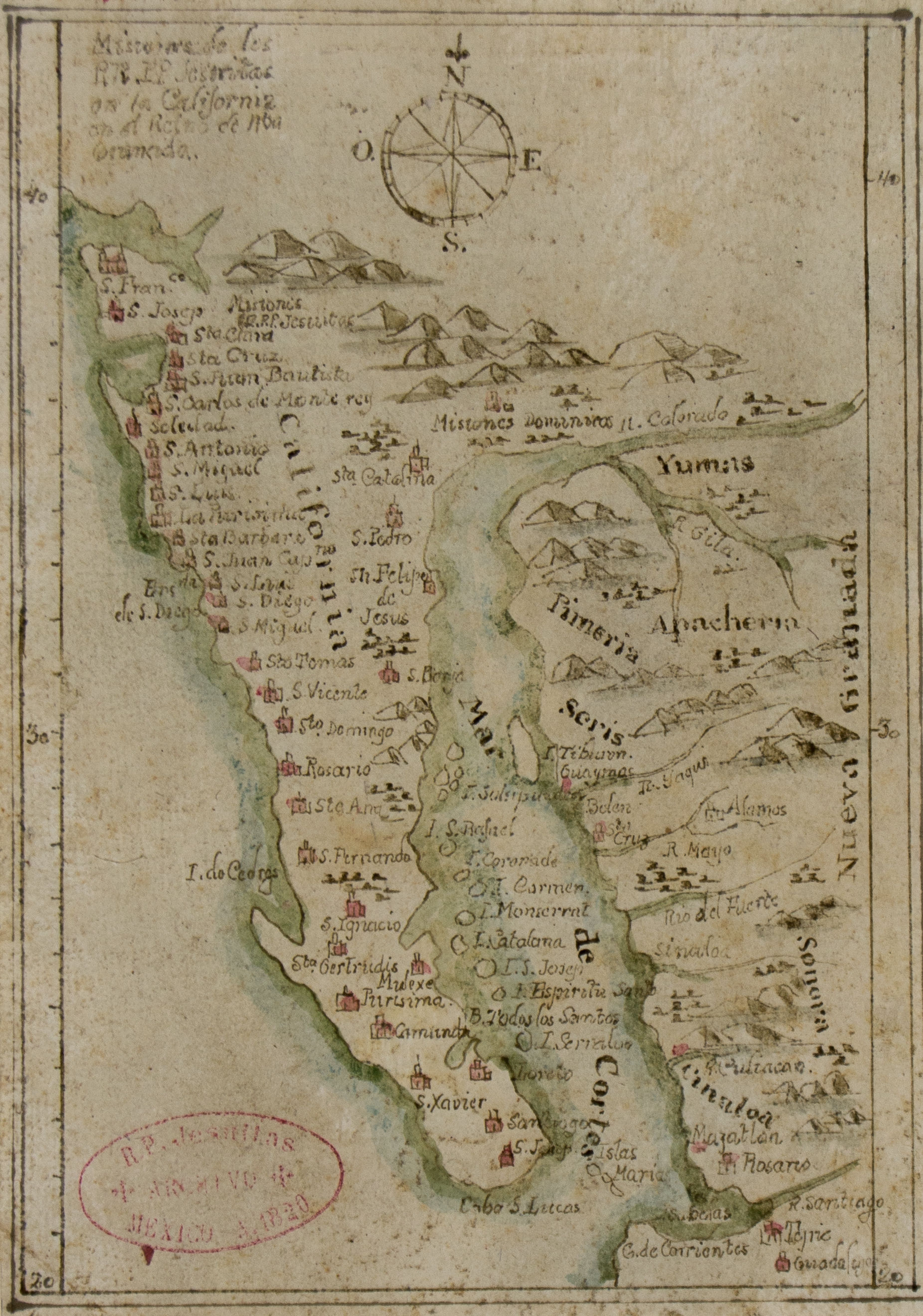
This rare map of California depicts early missions on the California coast. Catholic priests from both the Jesuit and Franciscan orders established these churches, and the creator of this map was likely a member of either brotherhood.
Departing For Parts Unknown
Having departed from Santa Fe two weeks earlier, the party was attempting a traverse of western North America to the recently-established Spanish settlement of Monterey on the Pacific Coast. Their path stretched through canyons, over mountains, across rivers, and beyond forests in a space almost wholly unknown to Spanish mapmakers. The expedition was led by two Franciscan friars, Fray Francisco Atanasio Domínguez and Fray Silvestre Vélez de Escalante. These fathers organized the expedition at the behest of their superiors—administrators who desperately sought to find ways to provision the remote corners of an expanding network of mission churches while also increasing the potential for making new converts among Indigenous peoples.
Conventional histories of the Domínguez-Escalante Expedition, as the undertaking became known despite the unfortunate shortening of Vélez de Escalante, have tended to situate the friars at the core. This practice has emphasized the Spanish, and by extension, European aspects of the expedition. The expedition nonetheless represented a critical encounter with Native America. Significantly, the friars enlisted a team that consisted of Indigenous participants with varying degrees of connection to Tribal communities along the route they traveled. These participants contributed in profound ways and, like the friars, engaged in the intercultural exchange that was perhaps the most lasting and consequential impact of the entire trip. For Indigenous communities, the arrival of these men marked the intensification of an era of change that would witness ever-increasing interruptions, emanating first from New Mexico and eventually from across the Great Plains.
The friars’ journey through Colorado and throughout present-day Utah and Arizona was aided by Native peoples who provided vital guiding services in a land that quickly lost all resemblance to New Mexico and which could have swallowed the party whole. Just days after visiting the ruins—likely those that now bear the name “Escalante” located behind the present-day Canyons of the Ancients Visitor Center and Museum—the expedition’s cartographer, Bernardo de Miera y Pacheco, became entirely lost in a canyonland that Vélez de Escalante called the “labyrinth of Miera.” Emerging from this expanse of stone, the expedition encountered Utes for the first time, securing the aid of a Ute man named variously Panchucunquibiran, or “Great Talker,” and Red Bear—later named Silvestre—on the way to Utah Lake. At around the same time, the travelers were joined by a young man they named Joaquín who would accompany them for their entire circuit back to Santa Fe. These men and a host of other Indigenous people would serve as collaborators and informants, routing the party through mountain passes and along water corridors in search of what lay in the distance. Without them, the expedition would have floundered and likely could have never escaped from the clutches of the Intermountain West as fall turned to winter. While the Domínguez-Escalante Expedition failed to complete its journey to California, it returned to New Mexico with a wealth of knowledge and experiences that served to broaden an appreciation of the immensity of North America.
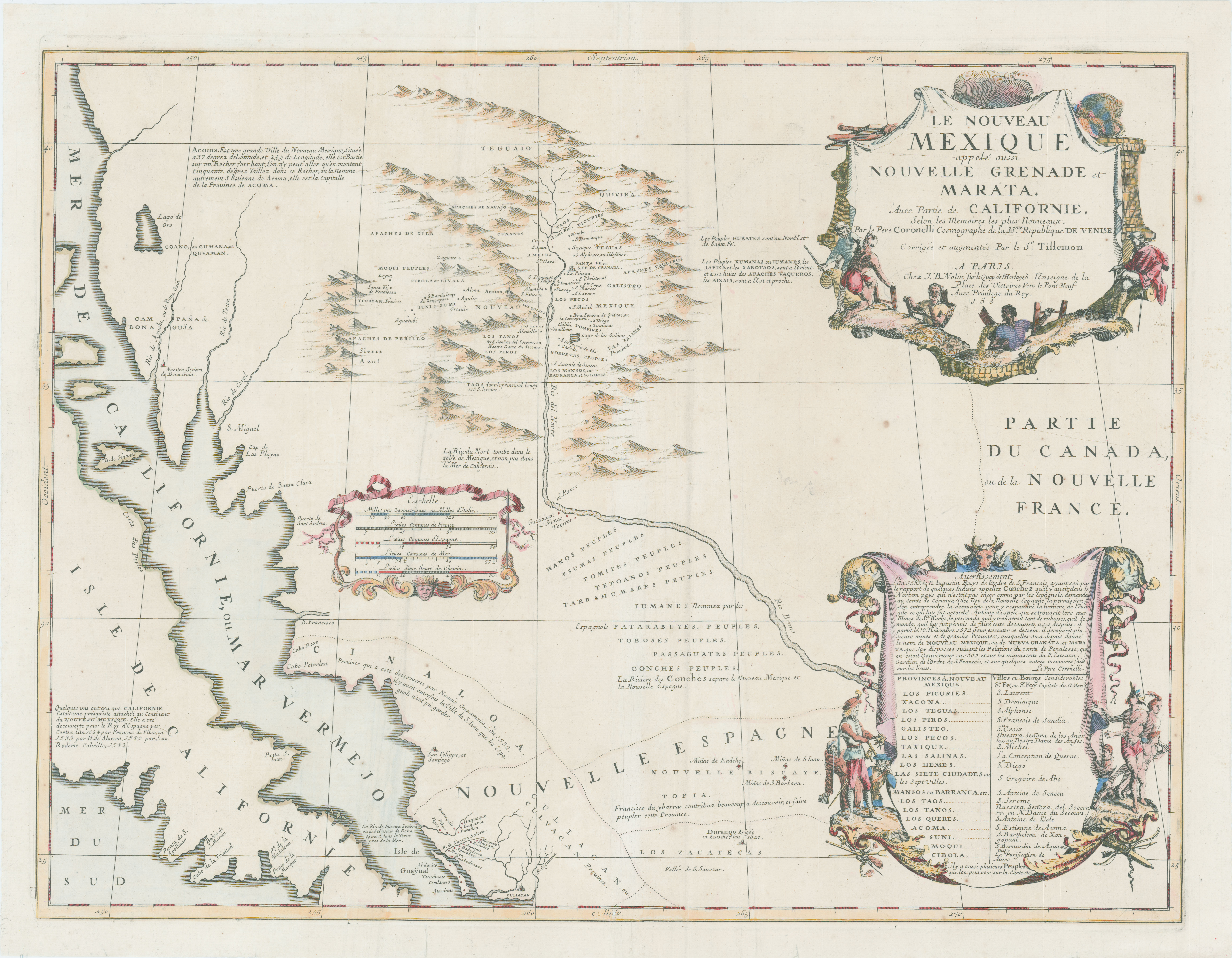
This map, the first to depict the Río Grande Valley as far north as Taos, shaped how Europeans thought about New Mexico for nearly a century. Note how the terrain surrounding the Río Grande Valley is blank.
The Domínguez-Escalante Expedition occurred at a moment in time when the Ute country came into clearer view for the Spanish. For generations, the Spanish kept a nervous watch on the northern frontier of New Mexico—a line of demarcation roughly equivalent to the contemporary Colorado-New Mexico border—viewing the Utes as a particularly warlike Tribe and seeking to limit contact that might provoke extended conflict. The 1760s saw the Ute country opened up to New Mexican explorers and traders, perhaps the result of the collapse of the informal Comanche-Ute alliance in place from the turn of the eighteenth century to its midpoint. Pushed westward by the Comanches, the Utes viewed closer ties to Spanish New Mexico as a strategic opportunity and evidently welcomed increased contact. Spanish governors meanwhile continued to enforce an official ban on trade with the Utes like other nomadic Tribes. But the visit of a Ute trader carrying an ingot of silver to Abiquiú in 1765 spurred great interest in the San Juan Range where it was supposed to have originated. The allure of wealth, the possibility of shoring up Spanish North America, and the mystique of the unknown all drew colonial attention—attention that ultimately sent a group of men trekking into the heart of Ute country.
Caught Between Necessity and Uncertainty
Along with rumors of silver and gold, the need to find an overland route to support new California missions spurred the search for a trail linking Alta California to New Mexico. Beginning in 1769 with the establishment of Mission San Diego de Alcalá (modern San Diego), the Spanish began an impressive spate of colonization along the California coastline. The effort followed, in part, from efforts to thwart Russian fur hunters migrating southward along the western seaboard. But projecting Spanish influence that far north taxed the reach of crown resources centered in Mexico City far to the south, so planners looked to New Mexico as a potential buttress. Already well over 150 years old—excepting years of abandonment after the Pueblo Revolt of 1680—New Mexican colonies were in New Spain’s northernmost zone of settlement. A thriving trade between Alta California and New Mexico, if it could be generated and protected, would serve as a mutually reinforcing development in the interest of commercial opportunity for both colonial zones. Despite evident returns, the precise distance between Santa Fe and the nascent capital of Alta California established at Monterey remained uncertain. More curious still was the variety and temerity of the Native Tribes that along the route.
Despite local knowledge and stories filtering into New Spain from Indigenous peoples in the area, Spanish knowledge of the Tribes of what would become Colorado remained shrouded in mystery, contributing to a sense of both uncertainty and excitement for the friars who were eager to preach the gospel to new peoples. New Mexicans were repeatedly banned from trading within the Ute country by Spanish governors intent on forestalling the sort of interactions that might provoke widespread conflict. This circumstance left information regarding the Ute bands—their language and distribution among the innumerable mountain ranges and watersheds of the North American West—uncertain and unreliable. Some members of the expedition knew at least the points of entry to modern Colorado, having accompanied the expeditions of Juan Antonio María de Rivera during the 1760s. Evidence suggests that these same men returned to the region to pursue tentative trade forays. But the friars would later chastise these same men for possessing a limited knowledge of the territory, their frustrations possibly hinting at the reality that the men had only visited the area on a limited basis. After all, Governor Tomás Vélez Cachupín (no relation to the friar) had authorized the Rivera expeditions fueled by the possibility for resource extraction and little desire to pursue conversion.
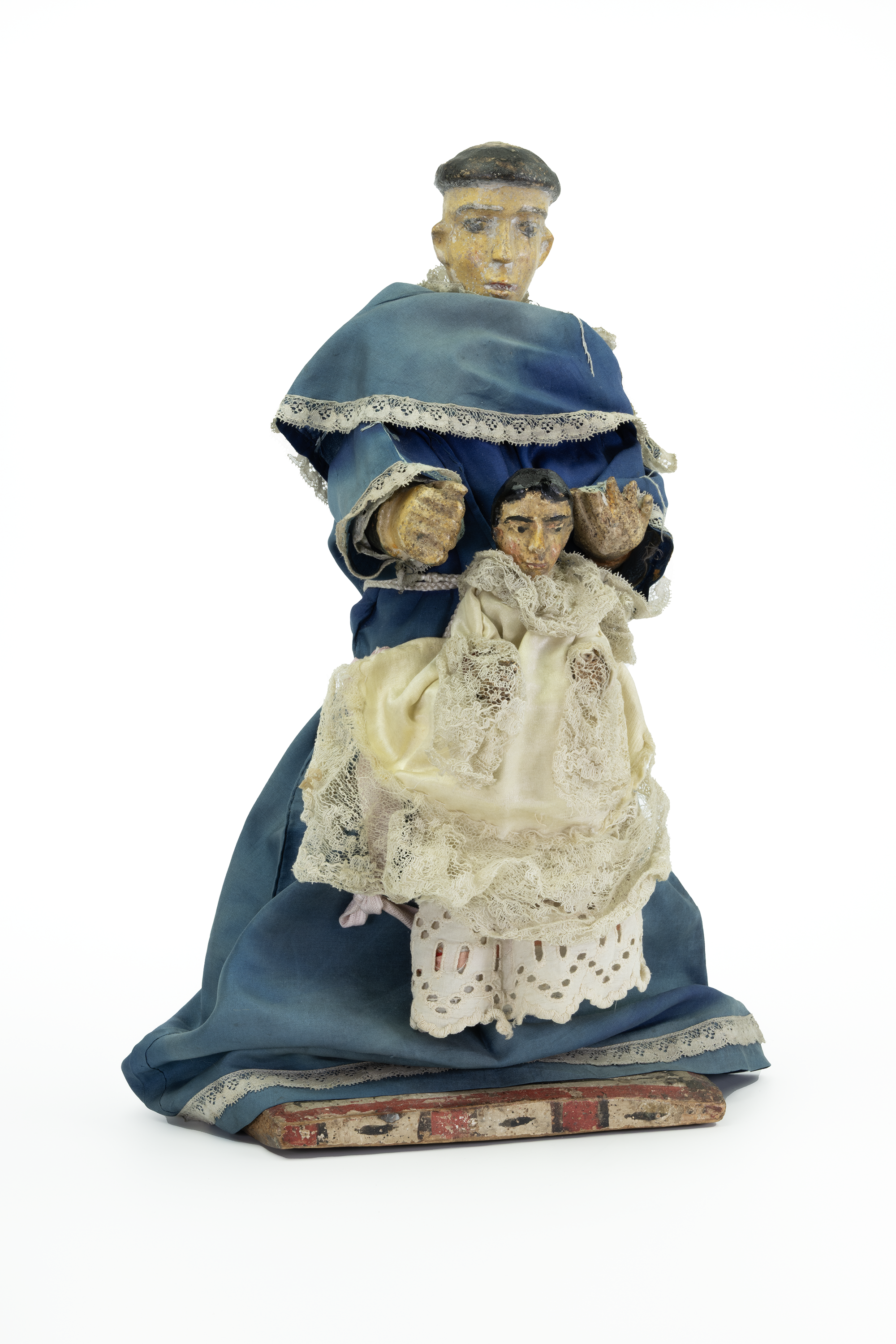
A bulto of Saint Anthony with the Christ Child. The tradition of carving bultos—wooden sculptures of Catholic saints meant as intermediaries between believers and the saints or dieties—originated in the Southwest and were commonly found in the region’s missions and churches.
At least in a few respects, the Domínguez-Escalante Expedition was a profound failure. It never made its way to the California coastline, reversing course in modern Utah after two months in the field. The return would take nearly another three months to complete through some of the roughest terrain in North America. Despite promises to do so, the friars did not return to missionize among the Utes or other Tribes for that matter. Indeed, despite a recommendation presented by Miera y Pacheco to King Carlos III himself encouraging the establishment of military garrisons in the Four Corners region and near Utah Lake, the Spanish did not extend their presence into the region in any substantial way. All the same, the geographic knowledge produced by the expedition was used by countless individuals to understand the region and plan for its conquest well into the era of US expansionism.
By contrast to countless other Spanish entries into North America, the Domínguez-Escalante Expedition was notably peaceful. Although the arrival of such a strange group unsettled some Indigenous communities who likely feared enslavement, the friars were temperate in their admonition of Native practices and often earned the respect of Tribal leaders even while proselytizing about a religious system so far removed from them. In the short term, relations with the Utes prospered and before the close of the decade Utes warriors campaigned with New Mexicans to police the continued pressure of Comanche expansion.
A Motley Mix of Travelers
Reflecting on the importance of the Colorado ruin that in time would carry his name, Vélez de Escalante conveyed a desire to contextualize the site in a frame that was still new to him, having lived in New Mexico for little more than two years among the Zuni. The ruin, which he described in the expedition journal as “a small settlement of the same type as those of the Indians of New Mexico,” presented an encounter with a world that was at once familiar and foreign. It also pressured him to consider that the expedition had entered Native space—distinctly non-European and ancient. Vélez de Escalante could hardly imagine the age of the ruin.
As he wrote, a short distance away the co-leader of the expedition, Domínguez, convalesced from a severe head cold that forced the party to halt for a day’s rest. Domínguez’s brush with malady was a harbinger of the rough days ahead in a terrain that grew increasingly harsh. Guided from July 29 to August 13 into modern Colorado by countrymen who previously had visited the region to explore its mineral and trade prospects, they approached a point where their knowledge of the land became increasingly sparse. The friars and their team stood on the cusp of a land unknown to them.
The Franciscan friars Domínguez and Vélez de Escalante have garnered the bulk of attention surrounding the expedition, but the actual group was much larger and encompassed a number of men with deep ancestral ties to North America. While formally sanctioned by Spanish officials, the expedition was not strictly Spanish in nature. The identity of the participants when considered collectively represented a cross section of New Mexico society. Only four participants in the expedition were born in peninsular Spain and might rightly be considered Spaniards in a formal sense. Vélez de Escalante hailed from the mountains in the north of the Iberian Peninsula. Three other peninsulares—Juan Pedro Cisneros, Joaquín Laín, and Miera y Pacheco—carried the honorific title of “Don” in the journal and had entered New Mexico during their lifetimes. Seven of the ten men who set out from Santa Fe were born in the Americas, and well over half of the expeditionaries taking in consisted of men possessing Native ancestry or who were in all possibility wholly Indigenous. Of this number, Domínguez was the odd man out as a native of Mexico City. The Muñiz brothers, Andrés and Lucrecio, appear to have had close ties to the Utes and moved rather fluidly between quasi-Native status and recognition as Spaniards. Andrés was the only person who stayed in the New Mexican hamlet of Ojo Caliente at the height of an intense cycle of Comanche raiding on that community, and in all possibility his Indigenous ancestry spared him from the worst. Andrés figured as the expedition’s principal interpreter. Simón Lucero may have been of Pueblo origin based upon his indenture to Cisneros, the alcalde, or district magistrate of Zuni. Juan de Aguilar’s place of birth at Santa Clara may hint at the participation of a second Pueblo. Only the identity of Lorenzo Olivares has remained shrouded in complete mystery.
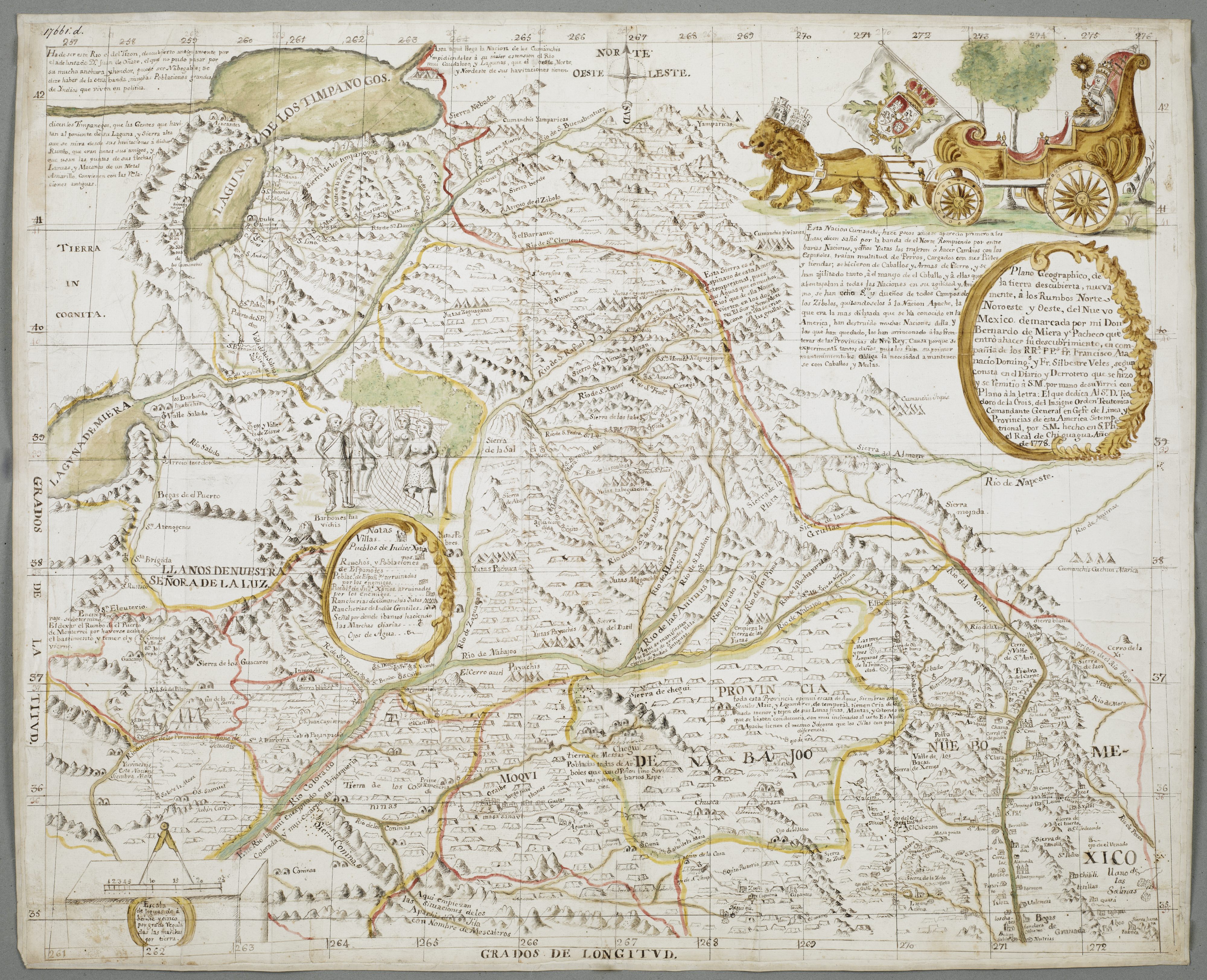
Miera y Pacheco’s map offered one of the first detailed European views of the American Southwest based on firsthand observation of the land. It became a vital tool for Euro-American colonial expansion.
At least two men who went by the name Felipe and Juan Domingo were genízaros, members of a community of detribalized Indians who inhabited Abiquiú on the far northwest corner of New Mexico at the juncture of New Spain’s remotest zone of settlement and the Ute country. For the better part of a generation, the genízaros of Abiquiú inhabited a key point of entry to New Mexico along the Chama River. Subject to intense religious scrutiny in the 1750s and 1760s for alleged ties to sorcery, the genízaros of Abiquiú represented a living reminder of New Mexico’s ties to a thriving trade in Indian slaves. Disconnected from their kin networks, they were nonetheless powerfully connected to the land and Native lifeways. Felipe and Juan Domingo—effectively stowaways but for lack of a seaborne route—joined the expedition on August 14, just after the party’s visit to the ruins on the Dolores River. Although the exact timing of their departure from Abiquiú is impossible to know, they likely shadowed the expedition for the better part of two weeks. The friars conceded their participation as companions in the expedition “to forestall the mischief which either through their ignorance or through their malice they might do by wandering any further.” Vélez de Escalante’s remark obscures the ties these men may have possessed to the region north of Abiquiú.
A Cultural Encounter
The Domínguez-Escalante Expedition presents clear indications of the shift in Spanish and Ute relations. On several occasions the friars preached to groups of would-be converts. Significantly the Ute responded politely, even suggesting an eagerness to learn more about Christianity. Taken from the vantage of 250 years, it would be right to question Vélez de Escalante’s description of these events and the encounter between Christian worship and Ute lifeways. The Utes and other Native peoples were eager to forge bonds with the Spanish that might facilitate trade and the language barrier limited a full appreciation of the friars' message. Significantly, the friars did not make demands of onlookers and do not appear to have diminished Native forms of worship except in the company of their fellow expeditionaries. Upon discovering that several men, Miera y Pacheco included, sought the aid of some Paiutes to cure the cartographer of an apparent malady, Vélez de Escalante reported in the journal that the two friars were “extremely grieved by such harmful carelessness and we reprimanded them.” Long-standing European beliefs associated contact with Indigenous persons as corrupting influence. The friars also reprimanded Andrés Muñiz for running an illicit trade with the Sabuagana Utes that they thought would undermine the religious message of the expedition. They were, in fact, quite dismissive of the value to be garnered from trade and harbored negative views of the intentions of traders among Indigenous peoples. In late October, Vélez de Escalante expressed the criticism that some of these traders “go after the flesh which they find here for their bestial satisfaction.”
The seemingly positive reception of their attempts at proselytization, on the other hand, filled the friars with great joy and contributed to their enthusiasm for the expedition. Among the Sabuaganas, Vélez de Escalante noted that “All assembled listened with pleasure.” Domínguez’s preaching of the gospel was interrupted by a man who offered an interpretation of the crucifix possibly derived from an earlier interaction with New Mexicans. Stunned by the man’s excitement as he stood “beating his breast with his hand,” the friars appealed to the Sabuagana chief to foster a path toward eventual conversion. At Utah Lake, the fathers had a fascinating exchange with the Timpanogos. There the friars explained their desire to build a mission nearby. According to Vélez de Escalante, “All [the Utes] unanimously replied that the padres should come…and that they offered all their land to the Spaniards for them to build their homes wherever they pleased.”
The friars likely misunderstood what the Utes meant to say to them. The journal suggests that the Utes made use of the reverential title of “tata” with the fathers in this instance, which suggests a warm reception. They were evidently excited by the arrival of the expedition and eager to establish a shared defence and promote trade. On September 25, the Lagunas presented a painted token of their affection that was later given to the Spanish governor at the completion of the expedition. The gift followed from a prompting on the part of the friars to obtain an indication of Laguna investment in their return. The desire of the friars to seek the return of a larger missionizing force appears to have been a common thread of their worldview, which served to frame their interactions with Native peoples. On October 2, Vélez de Escalante remarked: “They all replied very joyfully that we must come back with the other padres.” As they later abandoned the route to California and turned their attentions southward toward the canyonlands of the contemporary Arizona-Utah border, the friars were apparently filled with excitement for the prospect of evangelizing to the Cosninas, or Havasupai.
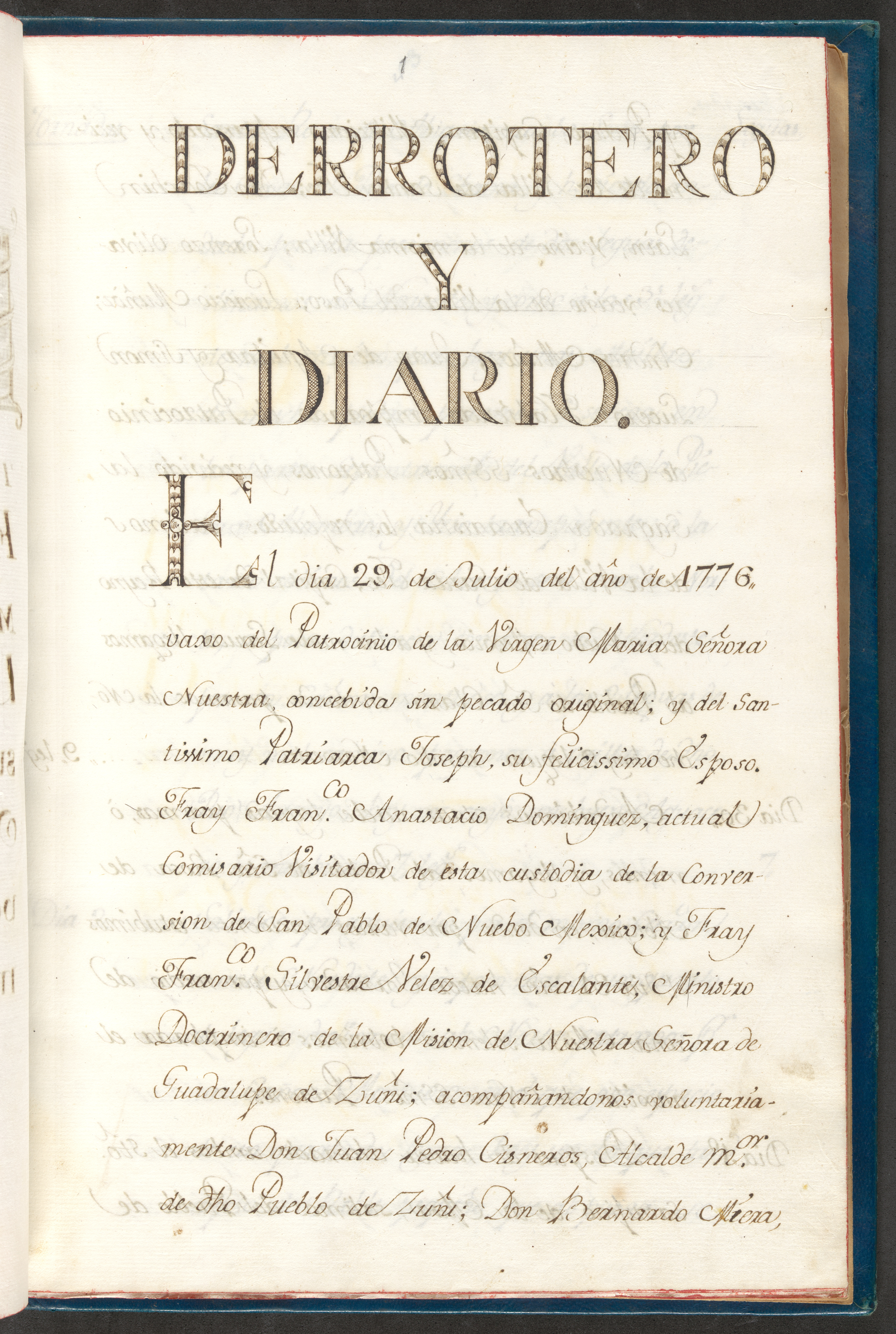
This is a page from Escalante’s journal of the expedition. Unfortunately, the original journal is lost, but this page comes from one of the oldest known copies.
Native Guidance
The expedition relied on several Ute guides to navigate through the interior of the Colorado Plateau and western Great Basin. Their participation represented the longest and most consequential cultural encounter of note. Of these men, Panchucunquibiran warrants enormous appreciation. A Timpanogos or Laguna as Vélez de Escalante referred to him, he made contact with the expedition at a moment when the knowledge of those men who accompanied Rivera into the north had reached its maximum extent, accompanying them into a Sabuagana Ute encampment in late August. The expedition floundered when the Sabuaganas quickly broke camp on September 2 and his intervention placed its participants on track to California once again. In a telling journal entry, Vélez de Escalante conceded “We did not know what direction to take.” Panchucunquibiran’s navigational skills were not without fault, so far as he was from the Utah Valley. On September 6, a dispute arose over the direction to take at a fork in the road. Laín and others protested a route chosen by Panchucunquibiran that they feared would take them too far north. A chance encounter with a Sabuagana encouraged a more westerly route. The Laguna man nonetheless directed the party over the Colorado River and through northwestern Colorado and eastern Utah before arriving at Utah Lake, flamboyantly returning to his people donning a blanket provided in exchange for his guiding services along with an all-purpose knife and white glass beads.
Panchucunquibiran held an important political role among the Timpanogos; described as a chieftain by Vélez de Escalante. In addition to his services as a guide, Panchucunquibiran secured the calm of his compatriots on the banks of Utah Lake. As the Domínguez-Escalante Expedition made its arrival at the shores of the lake, the Timpanogos confronted them with weapons in hand. According to Vélez de Escalante, Panchucunquibiran diffused the situation, providing to “them an account so much in our favor of what he had observed and witnessed ever since he had become one of us, and about our purpose in coming” and reporting “at very great length how well we had treated him and how much we loved him.” In this way, his involvement facilitated the entry of the expedition into the distant homeland of an unfamiliar Ute band and ensured a positive reception.
At around the same time that Panchucunquibiran joined the expedition, a young man, “still a boy” to Vélez de Escalante, fell into participation as well. Possibly an orphan, the young man quickly adopted a strong esteem for the fathers and came to be a consummate member of the expedition. Initially thrown on a saddle with Don Laín, Joaquín came to figure as one of the expedition’s ablest participants, in time calming Paiutes to extract critical navigational information and attempting to pilot a route across the Colorado River as the expedition feverishly struggled to exit the canyonlands along the Arizona-Utah border. In January 1777, Joaquín made his way to Santa Fe where he was presented to Governor Pedro Fermín de Mendinueta. What happened to him in subsequent years remains a mystery, though he may have returned to the Ute country. On campaign against the Comanche in the San Luis Valley in 1779, Spanish Governor Juan Bautista de Anza referenced the participation of men who accompanied the friars, but furnished no information to identify the men. Joaquín’s linguistic ability in Ute would have facilitated communication with the roughly 200 Ute and Jicarilla Apache who joined the campaign. In this regard, his service likewise would have been highly sought after by traders seeking to locate commercial outlets beyond Abiquiú.
That the Domínguez-Escalante Expedition took place amid a contest between European empires warrants little debate. Only very recently, scholars have begun to grapple with the reality that European imperial competition existed alongside confrontations with powerful Indigenous tribes. Historian Pekka Hämäläinen even has suggested that New Mexico functioned as a virtual satellite of Comanchería—a Spanish term for the Comanche homelands—in the late eighteenth century. Persistent raiding depleted the horse herd attached to New Mexico’s principal military garrison at Santa Fe, devastated settlements along the territory’s periphery, and drove a state of panic into the hearts of colonial administrators and residents alike. Expansionist pressures were similarly felt by the Ute. As the expedition traversed a portion of northwestern Colorado, Panchucunquibiran reported the departure of some Utes “who had moved out for fear of the Comanches.” The same pressures of Comanche expansion experienced in New Mexico were present among the several Ute bands that inhabited western Colorado.
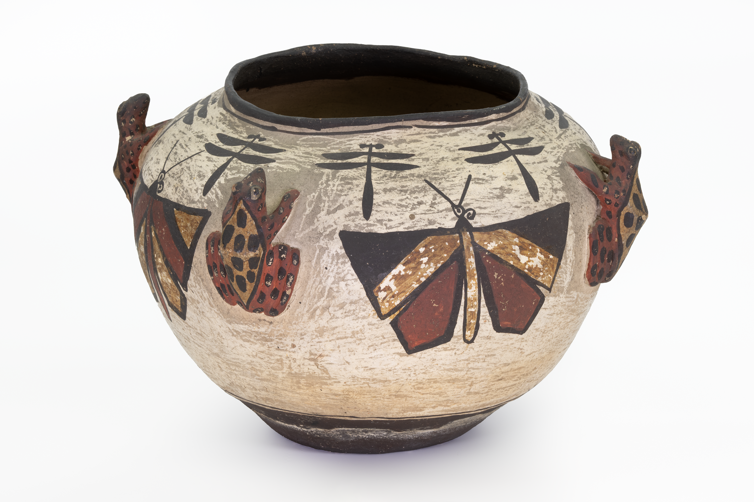
Ornate decorated pottery has long been an important part of daily life and cultural practice for Zuni peoples like those the expedition encountered on their journey.
Amid this crisis, the expedition ventured only lightly armed into an area north of the Colorado River that figured as a site of persistent conflict between the Comanche and Ute. On more than one occasion, the Ute cautioned the party to avoid venturing beyond the great river. Their fears might have referenced the proximity of the Shoshone and not the Comanche, though the Yamparika band of Comanche were known to be present in the region. The risk posed to the expedition points to the still-unconquered and independent nature of western North America after three centuries of Spanish presence. Not only was the land distinctly not Spanish, its status as Comanche or Ute remained an uncertain question and one undergoing active revision. The journal suggests repeated and long-term successes on the part of the Comanche in pushing deeper into Ute country, and the expedition found itself crossing land that was distinctly foreign in a political sense, doing so without seeking authorization to be there. From a Comanche point of view, the Domínguez-Escalante Expedition would have appeared a provocation and possibly even a threat.
The boldness of the friars in venturing into this space was not lost on Panchucunquibiran who remarked on their determination in a Laguna camp on the shores of Lake Utah. The friars claimed to be guided by a divine purpose that also protected them from harm. Meanwhile, the members of the expedition were nervous that Panchucunquibiran was leading them to an ambush. In the journal, Vélez de Escalante wrote that members of the expedition who were “conversant with the Yuta language tried to convince us that Silvestre was leading us by that route either to keep us winding about so as not to proceed further or to hand us over to a Sabuagana ambuscade that could be awaiting us.” On September 17, the site of tracks attributed to the Comanche sent a panic through the group. Boldness coexisted with an awareness that the expedition was far from home in a zone of conflict into which they might quickly be drawn. Vastly outnumbered and incapable of offering a robust defense, the expedition moved only at the mercy of the Tribes.
Mapping Native Space
Modern textbooks often replicate a problematic imaginary in their portrayal of North America in the later half of the eighteenth century. Enormous blocks of primary colors often demarcate the wishful thinking of European bureaucrats and do little to convey the real character of political boundaries in the continental interior. The practice of dividing North America among European powers overlooks the tenuous hold of distant bureaucracies in places such as London and Madrid. The maps produced by Miera y Pacheco shatter this convention by presenting a West divided by Native homelands, all situated within an elaborate patchwork of neatly organized homelands. In fact, western North America was not so neatly organized and the expedition traveled through areas where control was contested. Vélez de Escalante’s reporting makes evident that even northwestern Colorado, areas around modern day Meeker and Rangely, was a site of conflict between the Ute and the expansionist Comanche. South of Lake Utah, the variety of peoples encountered by the expedition became more evident and their permanence less evident.
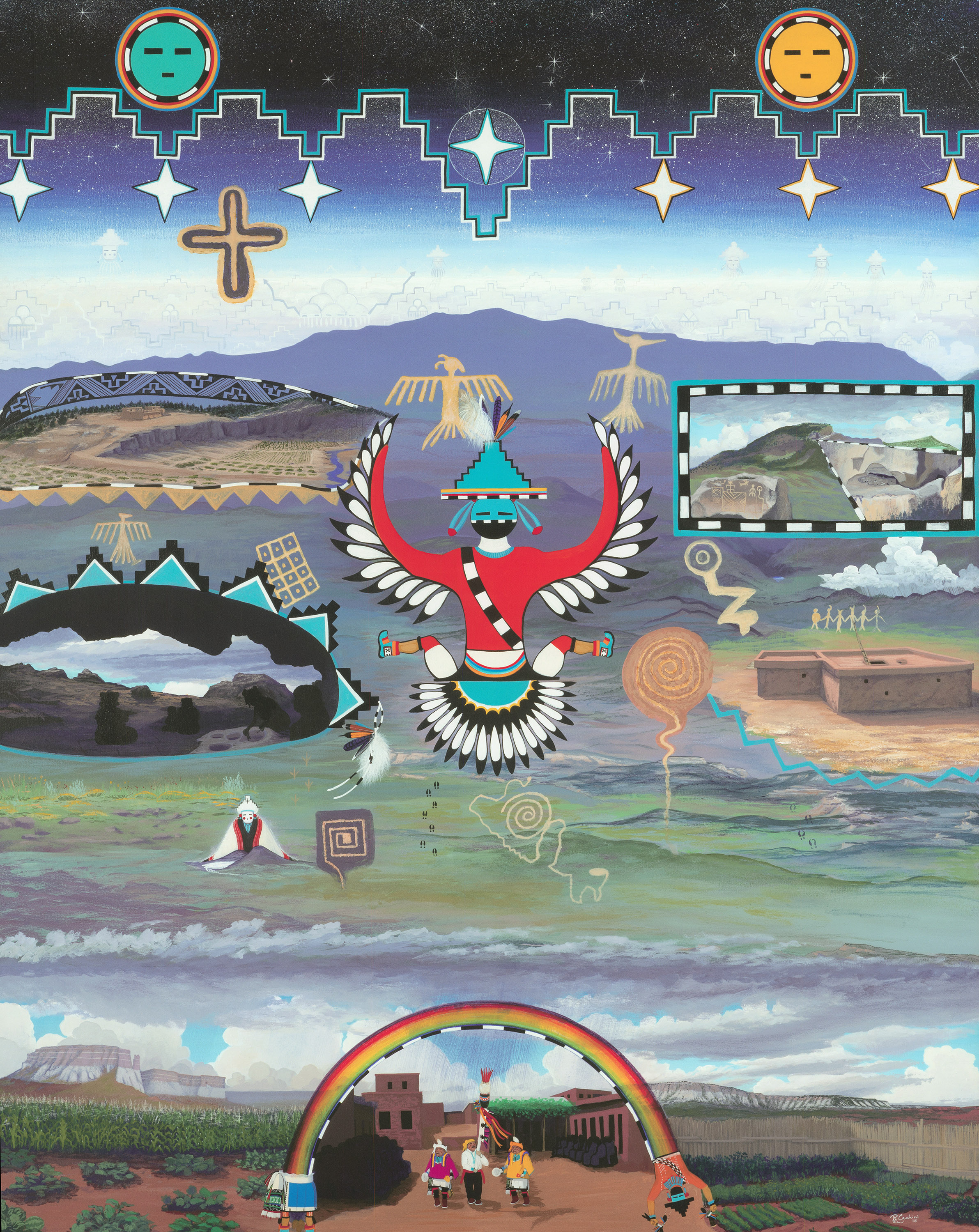
This map depicts the Reserve, New Mexico region. At the top, celestial elements hover above Eagle Peak, the region’s tallest sacred mountain. The middle brings to life key archaeological sites, portraying ancestors engaged in their daily work, alongside the Salt Woman deity guiding her people to essential salt resources. At the bottom, a harvest dance unfolds at Zuni Pueblo, with dancers gazing toward Reserve.
The neatly ordered maps we’re familiar with today reflect conventions of geographic organization familiar to Western mappers and the imagined extent of political states. Rarely do they reflect the lived reality of actual people until long after 1776. Although traversing western North America necessarily encompassed the crossing of Native borders, these boundaries were less fixed by comparison to European ones and often took shape as cultural expressions marked by the appearance of dress and language. In the course of the expedition, Vélez de Escalante remarked on the existence of Indigenous borders several times. For instance, near the border between the modern US states of Colorado and Utah he described the Green River as a border between Comanchería and the Ute country. In the Great Basin, he remarked on other borders suggesting for example on October 10 that “The full-bearded Yutas extended his far south, and here their territory ends apparently.”
Referencing these same full-bearded Utes, or Borbones as he labeled them, on October 13, he called attention to their border with the Huascari. Of the Huascari, he stated, “They border…along the northwest and north and employ their language, although with some variation.” That Vélez de Escalante chose to remark on these borders suggests that they were palpable frontiers experienced by the members of the expedition or perhaps features remarked upon by their Native guides. Alternatively, they may suggest a desire to impose order on a space that appeared fundamentally disordered from the perspective of the friars.
The maps likewise include geographic features derived from conversation with Native peoples. Communication in this regard was not always perfect. In one glaring error, Miera y Pacheco confused the pathways of the Green River and the Sevier River, suggesting a westerly flow toward the Pacific Ocean. The error, which appeared on his later maps, established the existence of a water course that did not exist and which would survive among cartographers for the next several generations. The error nonetheless speaks to Miera y Pacheco’s reliance upon Native American sources. It was precisely the knowledge of political boundaries furnished to him by Native people that framed early western conceptions of western North America. Baron Alexander von Humboldt viewed one version of the Miera y Pacheco maps in Mexico and later shared his memory of the document with none other than US President Thomas Jefferson. So it was that a prominent American expansionist came to understand the West.
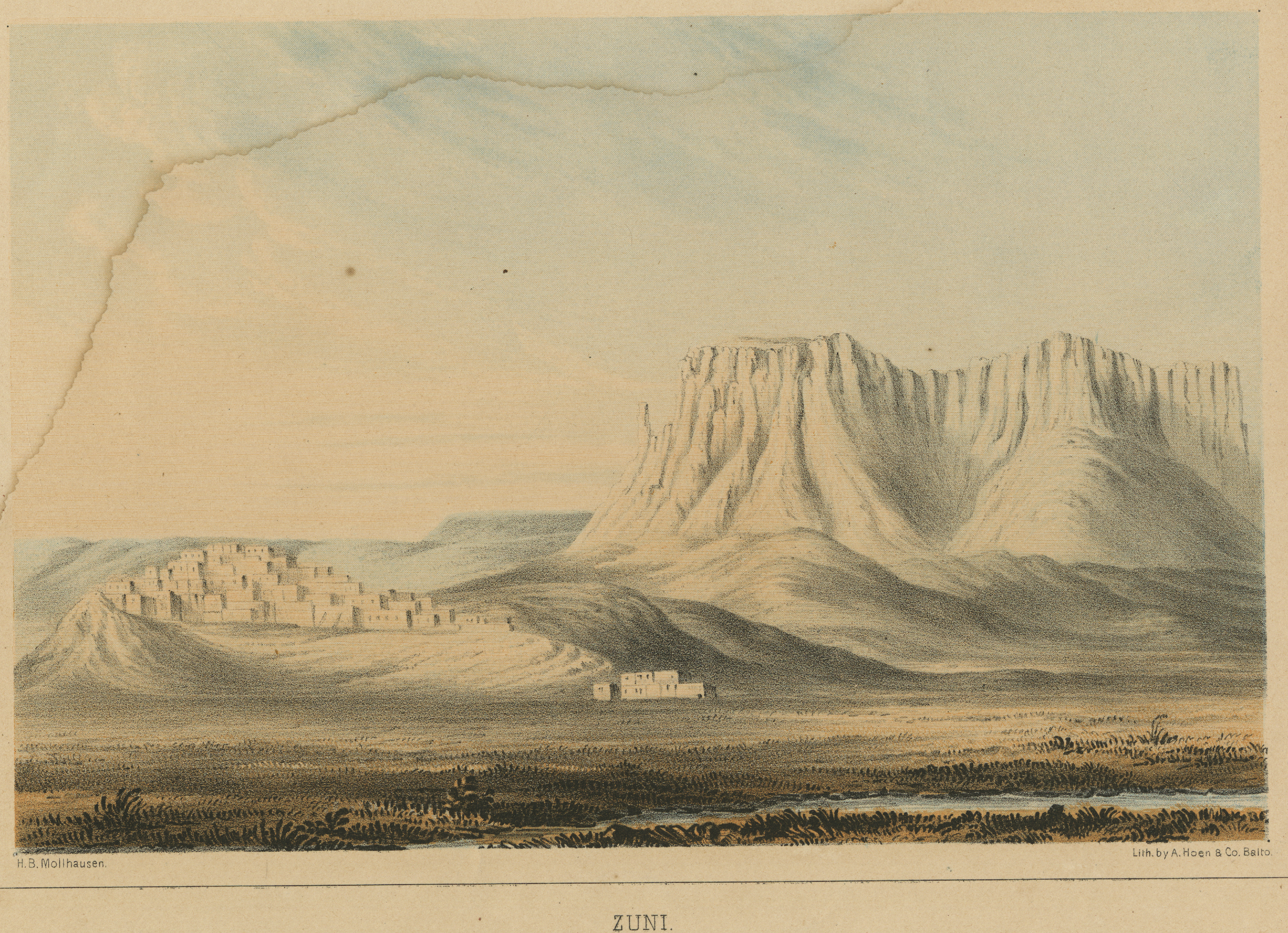
An image of the Zuni Pueblo, which the expedition visited in 1776. This image was created by German-born artist and illustrator H.B. Mӧllhausen in the late 1800s as American expeditions began encountering Puebloan peoples and their homes.
Making Colorado
As Colorado prepares to celebrate its sesquicentennial, the Domínguez-Escalante Expedition provides a window into a distant time and offers context for reflecting upon the difference a century can make. Two hundred fifty years ago, Colorado remained as it had been for thousands of years, a Native space still largely unknown to Westerners. In these years, Indigenous knowledge and wayfinding served as a vital component of attempts by Spaniards and New Mexicans to enter Colorado and find their way home. The relative success of an ostensibly European expedition depended upon Indigenous support. Within one hundred years, on the eve of Colorado statehood, the context had changed dramatically with Hispano settlements extending northward from New Mexico into portions of southern Colorado, Anglo communities rapidly taking shape along the South Platte River, miners steaming into Ute redoubts in the San Juan Range, and railroads crossing remote mountain pathways while ferrying still more newcomers into the region. The world experienced by the friars and their fellow voyagers had largely been undone.
Reflecting on the significance of the Domínguez-Escalante Expedition 250 years later, ample evidence exists to rank it first among several key episodes that explain the evolution of relations between Indigenous peoples and recent arrivals who have come to call Colorado their own. The friars and the men who accompanied them explored western North America with intent to recreate it in their image, making converts to Catholicism and establishing military outposts that would support the imposition of a new political order. In the end, their perceptions of this space were framed by interactions with Native peoples who likewise conveyed a sense of shared experiences—the Comanche threat foremost among them. With time, this comparatively more hospitable form of cultural interaction gave way to outright conquest. Two hundred fifty years later, we live in the afterworld that conquest created.